
The Netherlands and water
Wieringermeer and the 1945 Dyke Breach
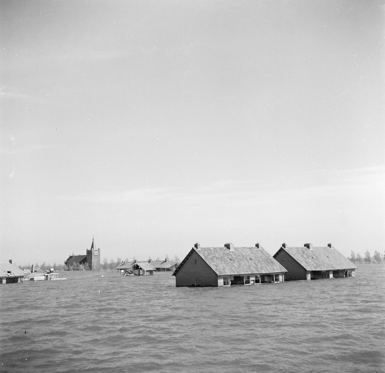
Wieringermeer had been dry for only fifteen years when the German occupying forces blew up the IJsselmeer dyke at two locations on 17 April 1945. Within two days, the young polder had become an inland sea again. Farms, houses, roads and almost the entire agricultural area disappeared beneath an average of approximately 3.75 metres of water. Behind the repaired dyke, two deep breach lakes, Dijkgatbos woodland and a monument mark the places where the water entered. Wieringermeer fell dry for the second time on 11 December 1945.

Why go here?
At the monument beside Noorderdijkweg, the consequences of the inundation remain directly present in the terrain. The repaired dyke makes a conspicuous curve around two deep breach lakes scoured out by the incoming water. Behind them lies Dijkgatbos, planted on sand deposited inside the polder during the breach. From the dyke, the higher IJsselmeer and much lower agricultural polder can be seen at the same time. The monument and dyke are freely accessible, while public paths provide access to parts of the woodland and the surroundings of the breach lakes.
What do you see?
You see a cube-shaped memorial beside the IJsselmeer dyke, the curved line of the repaired flood defence, two large breach lakes and Dijkgatbos. Walking paths lead through the woodland and beside parts of the water. From the crest of the dyke, the difference in level between the IJsselmeer and the Wieringermeer polder is clearly visible. The surrounding rectilinear agricultural landscape contrasts sharply with the irregular pools, relief and wooded sand deposits.
Why it matters
Wieringermeer is an exceptional example of land that had to be reclaimed from water twice. The first reclamation was a technical and social experiment within the Zuiderzee Works. The deliberate inundation of 1945 then demonstrated how vulnerable even a modern designed polder remained once its flood defence was opened. The breach lakes, curved repaired dyke and Dijkgatbos preserve not only wartime history, but also show how one brief hydraulic event could leave permanent forms within a strictly planned landscape.
The deeper story
Anyone travelling through Wieringermeer encounters an open and strikingly regular landscape of straight roads, long drainage channels, large agricultural plots and villages designed within a short period. Almost everything appears controlled and planned. This makes the site beside Noorderdijkweg especially moving. Behind the ruler-straight IJsselmeer dyke lie two deep, irregular pools and a woodland that formed no part of the original polder design. They were created when the young polder was deliberately flooded in April 1945.
Wieringermeer formed part of the Zuiderzee Works, the national programme intended to improve flood protection and create new agricultural land. Construction of the polder dyke began in 1927. The new flood defence enclosed approximately twenty thousand hectares of the still-open Zuiderzee.
On 10 February 1930, the Lely pumping station near Medemblik and the Leemans pumping station near Den Oever began removing the enclosed water. The lake bed officially fell dry on 21 August. Wieringermeer became the first large polder of the Zuiderzee Works and the only one reclaimed directly from the Zuiderzee before completion of the Afsluitdijk.
Settlement did not develop spontaneously after reclamation. Engineers designed straight roads, main canals, drainage ditches and agricultural plots. Farms received fixed positions on spacious holdings. Wieringerwerf, Middenmeer and Slootdorp were planned as new settlements. Colonists were also carefully selected for their professional skills, finances, family composition and suitability for pioneering life.
The first years were difficult. The soil had to mature, roads remained basic and many facilities were absent. Nevertheless, the polder rapidly developed into an important agricultural area. Grain, potatoes, beet and other crops grew well on the young soil. Within fifteen years, hundreds of farms, homes, schools, churches, warehouses and workshops had been constructed.
During the German occupation, the open polder acquired unexpected military significance. The occupiers regarded Wieringermeer as possible terrain for Allied airborne landings. From early 1945, preparations were made to inundate areas in several parts of the western Netherlands. Explosives were also installed in the Wieringermeer dyke. Fear of airborne landings probably played a role, although the exact military reasoning has never been fully clarified.
On 17 April 1945, residents were ordered to leave the polder. Around seven thousand inhabitants and an estimated one to two thousand people in hiding had only a few hours to gather possessions, move livestock and seek safety. Many struggled to comprehend that land reclaimed from the Zuiderzee only fifteen years earlier was to be surrendered to water again.
At approximately a quarter past twelve, explosives were detonated at two locations in the IJsselmeer dyke. The initial openings were relatively small, but incoming water rapidly cut through sand, clay and stone. The breaches became progressively wider and deeper. Within about two days, an estimated 700 to 750 million cubic metres of water entered the polder.
The average water depth reached approximately 3.75 metres. Roads, fields, farmyards and villages disappeared beneath a new surface of water. Only roofs, church towers, taller buildings and trees remained visible in some places. A small group stayed behind on De Terp, an elevated sand platform near Wieringerwerf. Others sought shelter on upper floors, in the government land office, on boats or at other elevated locations.
Storms on 20 April and in early May caused additional destruction. Buildings that had survived the initial influx were exposed to severe wave action. Walls collapsed, roofs disappeared and timber elements floated away. The monument beside the breach records that approximately eighty per cent of the buildings were completely destroyed. Machinery, supplies, household possessions and almost the entire 1945 agricultural season were also lost.
The water scoured two deep holes at the breaches. They reached depths of approximately twenty and twenty-six metres. An enormous quantity of sand was also deposited behind the dyke. The irregular pools and sand masses did not fit the straight polder pattern and remained visible after reconstruction as permanent scars.
Because residents had been warned shortly beforehand, the flooded polder did not suffer the large number of casualties that an unexpected breach might have caused. The evacuation was nevertheless chaotic and traumatic. Families were dispersed across Wieringen, West Friesland and other parts of North Holland. Many temporarily returned to relatives in the regions where they had lived before settling in the new polder.
Only eighteen days after the dyke breach, the German occupation of the Netherlands ended. Preparations for repair began almost immediately after liberation. Wieringermeer was important to food production and therefore received high priority. The great depth of the scour holes, however, made restoration along the original straight line particularly difficult.
Instead of completely filling the breaches, a new curved dyke was constructed around the holes. The two breach lakes consequently remained behind the new flood defence. The dyke was closed on 5 August 1945. Shortly afterwards, the Lely and Leemans pumping stations began removing the water with assistance from temporary Werkspoor pumps and powerful American equipment.
Wieringermeer fell dry for the second time on 11 December 1945. Mud, washed-up materials and the remains of buildings covered the land. The fact that the floodwater was relatively fresh IJsselmeer water proved an important advantage. The soil did not require years of desalination before agriculture could resume.
Reconstruction began almost immediately. Roads and bridges were repaired, emergency housing was erected and farms were rebuilt. Hundreds of families returned in the spring of 1946 and crops were harvested again that same year. Complete restoration of homes, shops, schools, churches and agricultural holdings nevertheless continued well into the 1950s.
The sand deposited behind the dyke during the breach was not entirely removed. Dijkgatbos was planted on the poor and irregular ground. A sheltered landscape of trees, relief, water and winding paths now lies behind the strict polder dyke. A cube-shaped monument beside Noorderdijkweg records the principal figures of the disaster.
First look across the IJsselmeer from the dyke and then turn towards the much lower polder. The difference in level makes it clear how rapidly the water could spread after the explosions. Then follow the curved line of the repaired dyke around the breach lakes. Wieringermeer was reclaimed once from the Zuiderzee, deliberately flooded fifteen years later and pumped dry again within eight months. Dijkgatbos and the two pools preserve the place where a carefully designed polder temporarily became a lake again.
Further reading
- Wieringermeer, monument op de NoorderdijkwegNationaal Comité 4 en 5 mei
- De Wieringermeer weer drooggelegdRegionaal Archief Alkmaar
- Inpoldering van de WieringermeerRegionaal Archief Alkmaar
- Inundatie van de WieringermeerNetwerk Oorlogsbronnen
- Het toen van nu: Gemaal LeemansGemeente Hollands Kroon