
The story of this place
From high ground to island
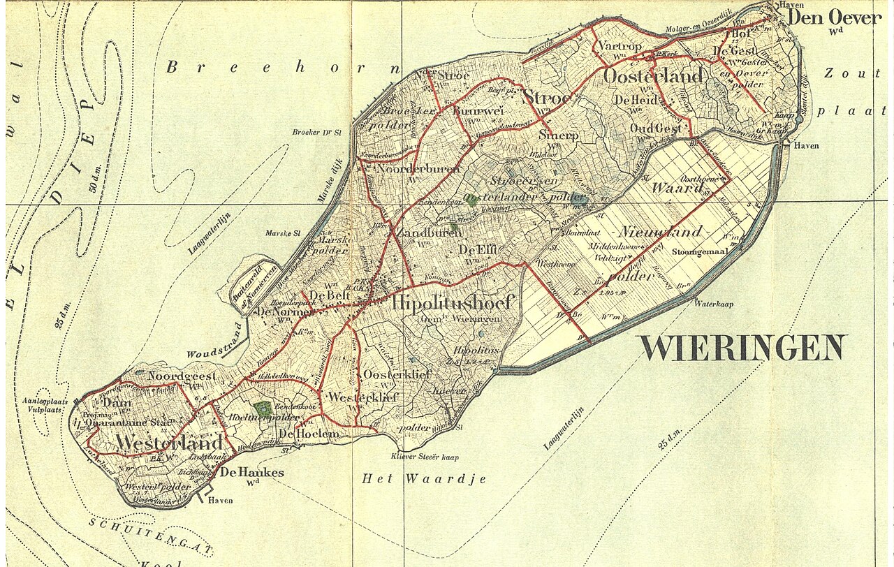
Wieringen now appears to be an ordinary projection of the North Holland coast. Roads connect Hippolytushoef, Westerland, Stroe, Oosterland and Den Oever with the surrounding polders and, by way of the Afsluitdijk, with Friesland. No crossing by boat is required. Yet this raised land was a separate island for approximately eight centuries. The land itself remains, but much of the water that defined its boundaries has disappeared or changed character.
The core of Wieringen consists of boulder clay and sand pushed up by land ice during an Ice Age. This created rolling ground that differs sharply from the flat peat and clay areas around it. Roads followed higher ridges and curved around lower ground. Farms and hamlets were scattered across safer elevations. This old foundation explains why Wieringen still looks more uneven and irregular than the surrounding polders.
Wieringen was not always an island. Around the eleventh century, erosion and storm floods removed large areas of the surrounding peat. Channels widened and the higher land became isolated. The Wadden Sea lay to the north, the Zuiderzee to the south and the Amsteldiep separated Wieringen from the North Holland coast in the west. A raised area within a larger peat landscape became an island.
Living with the sea
Water subsequently shaped everyday life. Inhabitants kept livestock on the higher ground, cultivated small fields and earned part of their living at sea. Fishing and shipping connected Wieringen with other islands, coastal settlements and trade routes. Den Oever developed as a harbour on the eastern side. Dykes were constructed along the vulnerable southern coast to protect lower land from the Zuiderzee.
The Wierdijk was a remarkable part of these defences. Thick layers of dried and compressed eelgrass were placed against the seaward side of an earthen dyke body. Wooden posts held the material in position. The dyke marked not only the boundary between land and water but also the edge of the inhabited island world. Mudflats, shallows and open water lay outside it; grassland, roads and farms lay behind it.
The islanders were not completely isolated. Ferries, fishing boats and cargo vessels maintained links with the mainland and other settlements around the Zuiderzee. Nevertheless, every journey depended on water, wind and tide. Goods, livestock and passengers had to be carried across. The sea was simultaneously a road, a workplace and a boundary.
The first fixed connection
At the beginning of the twentieth century, Wieringen became the starting point of an engineering project that would reshape the entire Zuiderzee region. After the Zuiderzee flood of 1916, the Zuiderzee Act was adopted in 1918. Before the main Afsluitdijk could be built, engineers constructed the Amsteldiepdijk between North Holland and Wieringen. This dyke, about two and a half kilometres long, served as a preliminary project. Engineers gained experience there with techniques and materials later used on a larger scale.
The connection was completed on 31 July 1924. Wieringen could thereafter be reached without a boat and formally ceased to be an island. The transformation was not yet complete in every direction. The Wieringermeer still lay to the south and the Zuiderzee remained open to the east. Even so, the first water boundary had been closed and the island had become attached to the mainland on one side.
Wieringermeer and Afsluitdijk
Further changes followed rapidly. From 1927, the Wieringermeer was enclosed and pumped dry. In 1930, an extensive former seabed emerged south and southeast of Wieringen. Straight roads, large fields, drainage ditches and newly planned villages replaced the water. Where generations had looked across the Zuiderzee, a flat and designed landscape suddenly appeared.
At the same time, work on the Afsluitdijk was taking place at Den Oever. The final opening was closed on 28 May 1932. The Zuiderzee subsequently became the IJsselmeer and Wieringen formed the western landfall of a permanent connection with Friesland. Within less than a decade, an island shaped by water for centuries became a link between old land, new polder and a national transport route.
The geographical change also transformed daily life. Fishing and shipping lost part of their central role. The enclosed water gradually changed from salt to fresh, and new work attracted labourers and settlers from elsewhere. Roads made overland movement ordinary. The transition from island to mainland therefore also ended a distinct way of life.
Where the island is still visible
Wieringen nevertheless did not become identical to its surroundings. Travelling from the Wieringermeer onto the former island, the straight lines of the polder give way to slopes, curves and irregular fields. The old villages do not occupy a planned grid but lie on ground shaped by soil and water. Hedgerows, rolling land, historic farms and narrow roads continue to reveal the former island landscape.
The contrast is especially clear near Westerland. From the high ground, the slopes of the old island overlook the flat new land. The boundary is no longer an abandoned shore marked by shells or harbour posts. Instead, it appears as a change in height, field pattern and scale. On one side lies a landscape that developed over centuries; on the other, a polder designed and constructed within a few years.
The vanished island world is therefore not tied to one ruin or monument. It survives throughout the shape of the land. Winding roads follow old ridges, the Wierdijk recalls a former water boundary and Den Oever retains its position as a harbour at the edge of open water. The Amsteldiepdijk, Wieringermeer and Afsluitdijk simultaneously show how that world was closed off and absorbed.
From Westerland, look beyond the villages and farms and focus on the transition in the landscape. Replace the fields and straight roads to the south in your mind with water reaching the horizon. What disappeared then becomes visible: not Wieringen itself, but the surrounding space that made it an island for centuries.