
Vanished places
The Lost Castle of Wijdenes
A castle belonging to Count Floris V stood near the former shoreline at Wijdenes during the late thirteenth century. The fortress supported his authority in West Friesland and probably existed for fewer than fifteen years. After Floris died in 1296, its commander surrendered the castle, after which the West Frisians demolished it completely. Coastal erosion and the later retreat of the dyke eventually left the former site beneath the water. Its precise location remained unknown for centuries. In 2025, rectangular structures and large medieval bricks on the bed of the Markermeer were located and convincingly identified as remains of the castle.

Why go here?
Wijdenes preserves the story of a castle that disappeared almost as quickly as it was built. It was not a peaceful noble residence, but a military and political instrument in the struggle between Holland and the independent West Frisians. After the death of Floris V, the fortress was surrendered and demolished. Even the former site later disappeared beneath the water. From the dyke, the Markermeer appears empty, yet its bed contains remains of one of North Holland’s most elusive castles.
What do you see?
From the West Frisian Ring Dyke you see the open water of the Markermeer, the low shoreline, grassland and the harbour of Wijdenes. Nothing from the castle is visible above water. Its remains lie on the lakebed and are not accessible. No walls, moats or castle mound can be recognised on land. The vanished fortress becomes legible mainly through the former shoreline, the strategic access from the water and the dyke that was later moved inland.
Why it matters
The castle of Wijdenes stood at a turning point in the history of West Friesland. Floris V used fortifications to control conquered territory, protect supply routes and enforce a permanent comital presence. The rapid demolition of Wijdenes shows that this authority was far from secure. Its underwater identification links political history with coastal erosion, water management and archaeology. A building intended as a symbol of domination was first dismantled by people and then hidden by the changing coastal landscape.
The deeper story
At the end of the thirteenth century, West Friesland was not yet an unquestioned part of the County of Holland. Its inhabitants defended their independence and repeatedly resisted the counts of Holland. The flat landscape of ditches, marshes and difficult routes made military campaigns costly and dangerous.
The conflict also had a personal dimension. Count William II, the father of Floris V, had died during a campaign against the West Frisians in 1256. His horse broke through the ice near Hoogwoud, after which he was killed. His body remained hidden for years. Floris grew up with the story of this defeat and made the expansion of his authority over West Friesland an important part of his rule.
In 1282, Floris launched another campaign against the West Frisians. According to tradition, his army landed at Wijdenes on the eastern side of the region. The site offered access from the water into Drechterland and the West Frisian interior. On 25 June 1282, Floris issued a charter from Wijdenes. This indicates that the comital fortification probably already existed or was at least usable by that date.
The castle was known as the House of Wijdenes or House of Widenisse. Little is known with certainty about its form. It was probably a brick fortification that accommodated a garrison and supplies. Whether it possessed towers, an outer bailey or several moats cannot yet be established reliably from the present evidence.
Wijdenes belonged to a series of fortifications through which Floris strengthened his position in North Holland. Comital castles also stood near Medemblik, Alkmaar and Krabbendam. They protected routes and strongpoints, but also carried a clear political message. A stone castle demonstrated that the count did not intend merely to pass through with an army, but planned to establish lasting authority.
To the West Frisians, the fortress must have been a forceful symbol of comital power. Its construction required brick, timber, labour and supplies. Movements along the coast and connections towards the interior could be watched from the stronghold. Its waterside position allowed provisions to arrive by ship.
Floris gradually extended his authority over West Friesland. A severe flood in 1287 weakened and isolated parts of the region. In the following years, more communities recognised his rule. Floris eventually had his father’s body recovered and transferred. An important personal and political objective appeared to have been achieved.
Peace did not last. Floris V was captured by nobles in 1296 and killed near Muiderberg. His death weakened comital authority and gave the West Frisians an opportunity to attack symbols of Holland’s domination.
The castle at Wijdenes was then commanded by Boudewijn van Naaldwijk. When the West Frisians advanced, he surrendered the fortress in exchange for his own safety and that of his family. The attackers subsequently demolished the castle. They then continued towards the House of Nuwendore and Medemblik.
The demolition of Wijdenes was apparently so thorough that the castle was never brought back into use. Only low foundations, loose rubble and scattered bricks probably remained. Precisely how much material was removed or reused elsewhere is unknown.
The coastal landscape also continued to change. Storms, waves and erosion attacked the land in front of Wijdenes. The Hofweide or Hofland, part of which lay outside the dyke during the fourteenth century, may have preserved the memory of the former castle grounds. After a severe flood, the dyke at Wijdenes was moved farther inland during the fifteenth century.
The former castle site may consequently have been left outside the new sea defence. Ground that had been dry or close to the shore during the thirteenth century then became a shallow lakebed. The building disappeared and eventually the site itself vanished from view.
For centuries, maps, field names and local stories provided only clues. Some representations included a castle-like symbol. Plots named Hofland were proposed as possible locations. None of these indications, however, produced convincing proof of the precise site.
Researchers began searching more systematically during the twentieth century. Drilling and other surveys were carried out on land, but revealed no clear castle foundations or moats. Early underwater research also failed to provide sufficient certainty. The House of Wijdenes therefore remained one of the great mysteries of medieval West Friesland.
During the 1990s, divers observed rows of large bricks on a sandy rise in the Markermeer. The bricks resembled medieval monastery bricks and may have formed parts of walls. Turbid water, currents and shifting sand later made the location difficult to relocate and survey accurately.
New research techniques changed that. Sonar and multibeam equipment allowed the lakebed to be studied in much greater detail. Rectangular patterns appeared. Volunteer divers then examined the location largely by touch because underwater visibility was almost nonexistent.
In August 2025, researchers announced that the site had been convincingly identified as the lost castle of Wijdenes. Large medieval bricks and structures on the bed formed rectangular patterns. The combination of location, material and form corresponded with what could be expected of the vanished fortress.
The identification does not yet answer every question. The exact size of the complex, the arrangement of its walls and possible towers and the quantity surviving beneath the sand have not been fully established. Further archaeological and geophysical research will be needed to determine the true design of the castle.
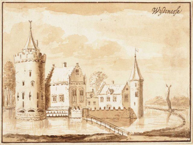
The familiar eighteenth-century drawing offers little assistance. Jacobus Stellingwerff created an imaginative depiction of a castle that had already been gone for more than four centuries. The image shows how later generations imagined the fortress, not what it can be demonstrated to have looked like.
Nothing from the remains can be seen from the dyke. The Markermeer stretches broad and open beyond the shore. Yet beneath the water lies a place where a castle was built, occupied, surrendered and demolished within a remarkably short period. The lakebed preserves not only the remains of a vanished fortress, but also a decisive chapter in the struggle between Holland and West Friesland.
Further reading
- Verdwenen kasteel van Wijdenes teruggevonden in het MarkermeerArcheologie in Nederland
- Duikers vinden in Markermeer precieze locatie van middeleeuws kasteelNOS
- Het verdwenen kasteel bij WijdenesOneindig Noord-Holland
- Van Aelbrechtsberg tot Wijdenes: kastelen in het dertiende-eeuwse landschap van Noord-HollandS. Erades