
The story of this place
Where the sea enters the dunes
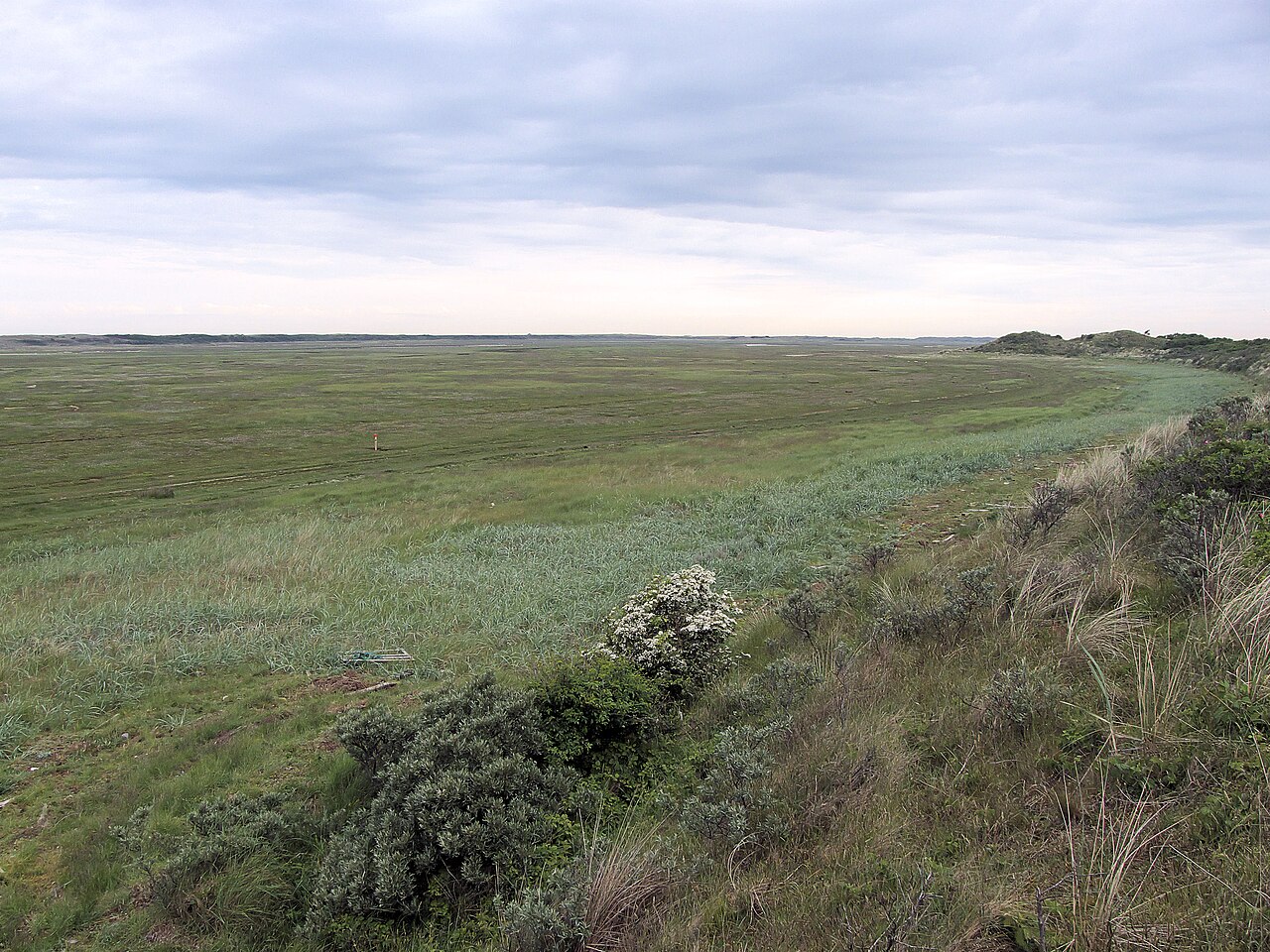
The Texel Slufter lies on the north-western side of Texel, between De Muy and the Eierland dunes. From the elevated viewpoint, it resembles a broad valley enclosed by dunes. A channel through the centre of the plain, however, connects directly with the North Sea. Seawater enters through this opening and spreads inland through a branching network of smaller tidal creeks.
At ordinary water levels, much of the plain remains dry or merely damp. The main channel and deeper creeks carry most of the water. During spring tides, north-westerly storms or exceptionally high water, the sea may penetrate much farther inland. Low areas then flood and the plain temporarily becomes a shallow inland sea. When the water retreats, it leaves salt, silt, sand and washed-up material behind.
De Slufter did not develop through natural coastal processes alone. During the nineteenth century, artificial dune ridges were built to enclose the beach plain between De Muy and Eierland. Storms broke openings through this new barrier. Most were repaired, but attempts to close the breach at De Slufter repeatedly proved vulnerable. At the beginning of the twentieth century, the decision was made to leave the connection with the sea open. Land intended for reclamation thus remained under tidal influence.
A landscape of salt and tide
Water and sediment continue to alter the landscape. Fine silt settles among plants in sheltered areas, while sand and banks are eroded elsewhere. Creeks shift their bends and new channels appear after high water. For a long time, the main channel was actively redirected whenever it moved too far north or south. The system is now being given more freedom to move naturally because this dynamic is an essential part of the landscape.
Salinity determines the vegetation. Glasswort grows on bare saline soil in the lowest areas, which flood frequently, and may turn red in autumn. Sea purslane and sea wormwood also tolerate salt and regular inundation. Slightly higher ground supports sea lavender, whose purple flowers may form large patches in July and August. Thrift blooms mainly in late spring and early summer with pink flower heads.
The plant zones follow subtle differences in elevation. A place only a few centimetres higher floods less often and supports different species. Low salt-marsh vegetation therefore gradually gives way to dune grassland and drier communities. This pattern reveals where seawater arrives most frequently, even though the plain appears almost level.
Creeks full of life
The creeks are important for animals. Shrimps, small crabs and young fish move inland with the rising water and retreat towards deeper sections as the tide falls. Pied avocets, oystercatchers and other waders search the muddy margins for bottom-dwelling animals. Common shelducks and other ducks feed and rest in shallow water.
The northern section is closed as a bird reserve. Common eiders, shelducks, avocets and other coastal birds find nesting sites free from continuous walking activity. High water remains a risk for nests on the ground. Outside the breeding season, migrants and winter visitors use the same plain for feeding and resting. Snow buntings, twites and occasionally shore larks then search for seeds among low vegetation and washed-up material.
Walking through a changing coastal landscape
The southern section can be reached by walking routes from the viewpoint. The ground below may be muddy, waterlogged or temporarily flooded. A creek that looks small at low water may become much wider and deeper after a high tide. Sturdy footwear and attention to weather and water levels are therefore sensible. The northern reserve must not be entered.
The structure of De Slufter is clearest from the viewpoint. The main channel approaches from the sea, winds inland and divides into finer lines. Close to the ground, other signs become visible: salt on leaves, fresh silt along a bank, bird tracks in the mud and debris marking the height reached by the water.
Each season alters the appearance. Breeding birds return in spring as the salt marsh produces fresh green growth. Sea lavender and thrift flower during summer. Glasswort and dying vegetation turn red and brown in autumn as birds migrate along the coast. In winter, the bare pattern of the creeks, winter birds and the effects of storm tides become more apparent.
De Slufter shows that coastal nature does not always develop by excluding the sea. Here, the open connection is essential. Without regular flooding, salt-marsh plants would disappear, the creeks would gradually fill and the plain would become a different landscape. What is resisted as a threat elsewhere keeps nature moving here.
What can you see when?
The months below show when a sighting is most likely. Wildlife remains unpredictable.
Sea lavender
In July and August, the small purple flowers can colour large parts of the salt marsh. Their abundance and exact locations vary from year to year with flooding, salinity and the deposition of sand and silt.
Thrift
Pink flower heads appear mainly in late spring and early summer on slightly higher parts of the salt marsh, where the soil remains saline but floods less often.
Glasswort
Glasswort grows low on bare ground that is regularly flooded. The plants are bright green at first and may turn red to deep red in September and October.

Common eider
Common eiders breed mainly in the closed northern section. After hatching, females and ducklings may gather in the broader channels, usually well away from accessible paths.
Common shelduck
All yearCommon shelducks can be seen along the channels and muddy margins for most of the year. Pairs and families occur in spring and summer, while larger groups are more common outside the breeding season.
Pied avocet
Pied avocets feed in shallow water and along muddy margins, sweeping their upcurved bills from side to side. Breeding birds are found mainly in quiet, closed parts of the reserve.
Waders
During spring and autumn migration, a variety of waders search the muddy margins and shallow creeks for worms, small crustaceans and other invertebrates.
Snow bunting
In the colder months, snow buntings may move in small flocks across bare sandy areas and low salt-marsh vegetation. They often become noticeable only when they take flight.

Twite
Twites occur mainly in autumn and winter, feeding in flocks on small seeds among low salt-marsh vegetation. Their muted plumage blends easily into the winter ground.
Shore lark
Shore larks are scarce winter visitors to low open vegetation and sandy salt-marsh margins. A sighting remains special and usually requires patient, prolonged searching.
Peregrine falcon
Outside summer, a peregrine falcon may hunt over the open flats. A sudden burst of ducks or waders into the air can reveal the raptor’s presence.