
The Netherlands and water
The Noordhollandsch Kanaal
Between Amsterdam and Den Helder runs a canal that ranked among the world’s largest shipping works when it opened in 1824. King William I ordered its construction because large sea-going vessels found it increasingly difficult to reach Amsterdam through the shallow Zuiderzee. The almost eighty-kilometre waterway was equipped with locks, towpaths and unusual floating bridges and was wide enough for merchantmen and warships. After little more than half a century, it lost its principal role to the North Sea Canal, yet its broad line of water still shapes much of the North Holland landscape.

Why go here?
The Noordhollandsch Kanaal is best understood by following part of the route beside the water. At Koedijk, the broad canal, former towpath and a working floating bridge can be seen close together. Farther north are three more floating bridges, followed by villages, locks and long canal embankments. No museum, admission ticket or guide is required. A short stop reveals the bridge and canal profile, but a cycling or driving route makes its scale and influence on the landscape much clearer.
What do you see?
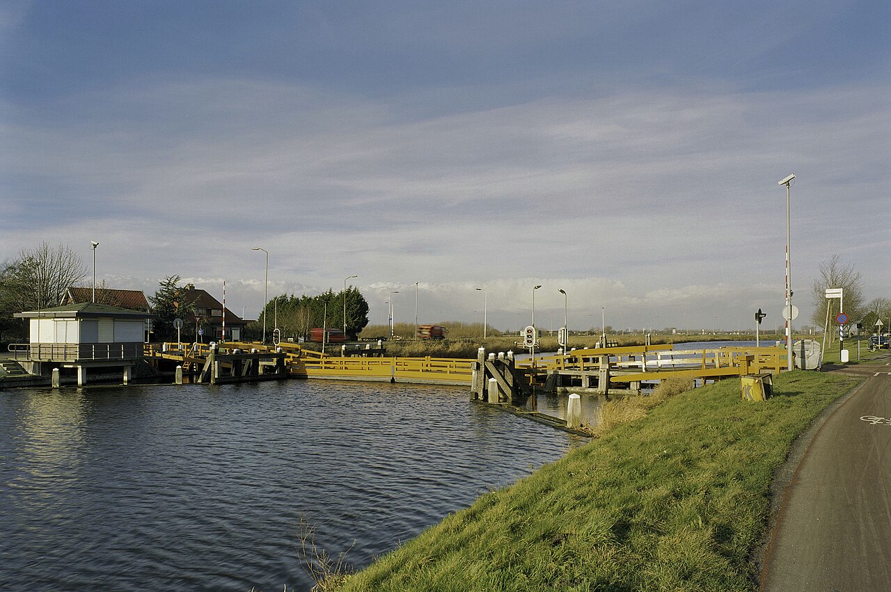
At Koedijk, the canal forms a broad, straight watercourse beside the elongated village. The Koedijk floating bridge rests on floating sections and slides sideways to allow vessels to pass. Roads and low embankments follow the former towpaths beside the water. To the north and south, long sightlines, bridges, locks, quays and ribbon settlements continue the canal landscape. Large sea-going vessels no longer pass here, but inland shipping, recreational boating and water management keep the waterway in use.
Why it matters
The Noordhollandsch Kanaal was one of the largest Dutch infrastructure projects of the early nineteenth century. Existing waterways, lakes and ditches were connected, widened and deepened into a continuous route for sea-going vessels. The canal reveals how urgently Amsterdam needed a reliable connection with the open sea before a direct passage to the North Sea became feasible. Although the waterway lost its principal function after little more than fifty years, it permanently changed the infrastructure, water management and settlement pattern of North Holland.
The deeper story
At the beginning of the nineteenth century, Amsterdam still bordered the IJ and the Zuiderzee, but its connection with the open sea had become increasingly difficult. The channels across the shallow Zuiderzee were silting up, and large merchantmen and warships struggled to reach Amsterdam harbour. Ships had to wait for favourable water levels, unload part of their cargo or be carried across the shallows near Pampus with special equipment.
One well-known emergency solution was the ship camel. A large vessel was clamped between two floating tanks. After water had been pumped out of the tanks, the ship floated slightly higher and could be hauled across the shallow passage. The system worked, but it was slow, expensive and cumbersome. A trading city that wished to compete with other European ports needed a more reliable route.
After the creation of the Kingdom of the Netherlands, King William I invested heavily in canals, roads and harbours. New infrastructure was intended to stimulate trade and industry and strengthen the cohesion of the young kingdom. For Amsterdam, he sought a waterway that avoided the most difficult section of the Zuiderzee and could lead large ships from Den Helder towards the capital.
Engineer Jan Blanken designed a route from the IJ near Amsterdam through Waterland, Purmerend, the Schermer, Alkmaar and the Zijpe to Nieuwediep near Den Helder. A growing naval and commercial harbour with direct access to the North Sea had developed there. On 15 April 1819, William I authorised the construction of the Groot Noordhollandsch Kanaal by royal decree.
The waterway was to be almost eighty kilometres long, approximately 37 metres wide and deep enough for heavy merchant vessels and ships of the line. An entirely new canal was not excavated throughout. Existing waterways, ditches, lakes and natural channels were connected, widened and deepened. New straight sections were dug between these older waters. The canal consequently contains long geometric lines as well as bends that follow earlier landscape structures.
Construction brought thousands of labourers to North Holland. These so-called polder workers came from several Dutch regions and neighbouring countries. Using spades, wheelbarrows, dredging machines and simple lifting gear, they removed enormous quantities of clay, peat and sand. The work was arduous. The ground was soft, banks could collapse and much of the route crossed wet polders.
Near Amsterdam, the peat soil caused particular difficulties. Existing waterways had to be deepened without allowing the banks to subside. Elsewhere, the canal crossed several regional and polder water systems. New locks and other hydraulic works not only had to pass vessels but also control differences in water level and the influence of salt water. The canal was therefore both a shipping route and a major intervention in North Holland’s water management.
The broad line of water divided existing roads and villages. Ordinary drawbridges were unsuitable because sailing ships with high masts and rigging needed a clear passage. Jan Blanken therefore developed the floating bridge: a low roadway resting on pontoons that could be moved sideways out of the shipping channel. Four floating bridges remain at Koedijk, Sint Maartensvlotbrug, Burgervlotbrug and ’t Zand. The present structures have been renewed but retain the unusual opening principle.
Large vessels could not simply sail through the canal. Its limited width, bends and changing winds made that too uncertain. They were therefore hauled from the bank by horses. Towpaths ran along much of the canal, where long teams of animals walked ahead of each ship. A heavy sea-going vessel sometimes required dozens of horses. At bridges, locks and sharp bends, the towlines had to be detached and fastened again.
The journey between Amsterdam and Den Helder took several days. Changeover points, stables, inns and moorings developed along the route. Horses could be replaced there, while crews and hauliers ate and stayed overnight. The canal was therefore more than an excavated waterway. It created an elongated working landscape of people, animals, bridge keepers, boatmen and small businesses.
On 13 December 1824, the frigate Bellona entered the new canal from the IJ. Horses hauled the warship northwards, and it reached Alkmaar several days later. At the same time, a merchant vessel left Den Helder for Amsterdam. These inaugural journeys were intended to demonstrate that large ships could indeed be led across North Holland.
At its opening, the Noordhollandsch Kanaal ranked among the largest canals in the world. Amsterdam gained a far more reliable connection with the North Sea, while Den Helder developed further as an outer harbour. Ships arriving from Asia, the Americas and European ports entered the canal at Nieuwediep and continued through the low polders towards the capital.
The limitations were nevertheless apparent from the beginning. The route was long and depended on horses, bridge operation and locks. Large vessels could pass one another only at specially widened sections. Congestion, damage, fog and bad weather caused further delays. Sea-going ships also became steadily larger during the nineteenth century. A canal that had seemed exceptionally spacious in 1824 soon became too narrow and shallow.
Widening and deepening would have been extremely costly and would not have removed the long detour through Den Helder. Meanwhile, new dredging techniques made a shorter route through the dunes near Velsen possible. The North Sea Canal between Amsterdam and IJmuiden opened in 1876. After little more than half a century, the Noordhollandsch Kanaal lost its position as Amsterdam’s principal sea route.
The waterway nevertheless remained important for regional inland shipping and water management. Agricultural produce, building materials, fuels and other goods continued to move by boat. Yards, businesses and transhipment sites remained beside the canal. The movement and discharge of water through North Holland also continued to be an important function. New bridges and alterations allowed modern inland vessels to keep using the route.
The canal also changed the form of the landscape. Villages expanded along its banks and near crossing points. Names such as Sint Maartensvlotbrug and Burgervlotbrug refer directly to the infrastructure. Roads follow canal embankments and former towpaths for kilometres. At Koedijk, houses, road, floating bridge and water stand so close together that the nineteenth-century canal landscape remains immediately recognisable.
At Koedijk, notice more than the floating bridge. Look at the broad waterway and the road beside it where the horses once walked. When the bridge moves sideways, the long line of water is briefly opened completely. Then imagine a heavy sea-going vessel being hauled slowly between the low polders towards Amsterdam. The Noordhollandsch Kanaal was not a permanent solution, but it was an extraordinarily ambitious intermediate stage in which manual labour, horse power and early hydraulic engineering together created a new road to the sea.
Further reading
- Wat weet jij over het Noord-Hollandsch Kanaal?Noord-Hollands Archief
- 200 jaar Noordhollandsch KanaalProvincie Noord-Holland
- Het Noordhollandsch KanaalRegionaal Archief Alkmaar
- Het Noordhollandsch KanaalOneindig Noord-Holland