
Stil eropuit
The Netherlands Beneath Your Feet
Back to map

See something ancient

House of Nuwendoorn

Near Krabbendam lie the marked remains of the House of Nuwendoorn, a medieval stronghold associated with Count Floris V. Wall outlines, traces of the moat, open polder land and a modern tower show how Holland’s authority was fixed here in stone and sightlines. The castle disappeared from view for centuries, until old medieval bricks revealed the hidden place of power again in 1948.

See something ancientPower & ruinsCastle ruinHeritage site
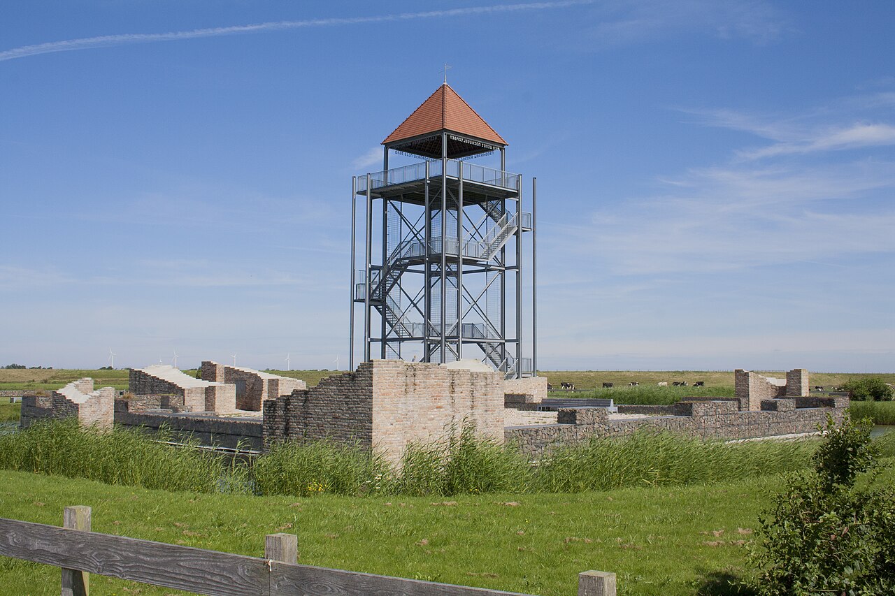
House of Nuwendoorn near Krabbendam with visible wall remains and a modern lookout tower.
The marked remains of the House of Nuwendoorn near Krabbendam, with the modern tower on the site of the former residential tower.Photo: EdwinH, via Wikimedia Commons, CC BY-SA 4.0Changes: No changes.

Why go here?

Walk among the low wall outlines and then look out across the open land towards the dyke and polder. Nuwendoorn makes a medieval place of power tangible without a complete castle still standing. The combination of foundations, moat, openness and height shows why a stronghold of control was built here.

What do you see?

You see the outlines and partly rebuilt remains of a medieval castle, with moats, an open site and a modern steel tower on the site of the former residential tower. The terrain lies in the West Frisian polder landscape, close to old dyke and water structures. The tower forms a clear landmark, but climbing it depends on current access arrangements.

Why it matters

Nuwendoorn is a rare tangible trace of Holland’s formation of power in West Friesland. The ruin connects Floris V, stronghold politics, waterways, dykes and West Frisian resistance in one open landscape. The fact that the castle had almost disappeared for centuries and was only recognised again in the twentieth century makes the place especially powerful: here, authority lay literally hidden beneath the polder soil.

The deeper story

The House of Nuwendoorn near Krabbendam is a place where the landscape seems quieter than the history beneath it. Today there are low wall outlines, moats and an open site with a modern steel tower. In the late thirteenth century this was not a romantic castle, but a coercive stronghold: a structure intended to make the authority of the count of Holland visible and tangible in a region that did not submit easily.

The castle is associated with Count Floris V of Holland. During the second half of the thirteenth century, he tried to strengthen his power in West Friesland. The region had a strong identity of its own and resisted Holland’s domination for a long time. Its land, routes and waterways were of great strategic importance to the counts of Holland. To the West Frisians, that expansion meant pressure from outside. Nuwendoorn stood at the centre of this conflict.

Construction is generally dated to around 1282. The site was chosen near old waterways around the Rekere and close to the landscape of the West Frisian Ring Dyke. In this flat and wet terrain, height and visibility mattered greatly. Whoever held a fortification here could observe movements by land and water and guard important approaches. Its position was therefore not accidental, but an essential part of the authority the castle was meant to project.

Nuwendoorn was more than a small fortified farmstead. The complex consisted of a residential tower, a main castle and an outer ward. The tower had a ground plan of approximately 11 by 11 metres. The main castle measured about 32 by 32 metres. Its walls, moats and towers made clear that the count did not intend merely to appear in the region temporarily, but to establish his authority there permanently.

After the death of Floris V in 1296, the meaning of the castle changed. During a period of West Frisian resistance, the complex was damaged or destroyed, although it is not known how completely. It was later repaired or rebuilt. After 1366 or 1367, however, Nuwendoorn disappears from accounts and archives. A storm surge or changes in the landscape may have contributed to its eventual decline.

The castle did not remain as a recognisable ruin above the grass. Its walls disappeared and the site faded from everyday memory. Only in 1948 did large medieval bricks in the soil reveal the remains again. What appeared to be empty polder land turned out to conceal a medieval centre of power. Archaeological research reconnected the name, the location and its history.

Parts of the wall outlines were later made visible. The modern steel tower marks the position of the former residential tower without suggesting that the medieval structure has been rebuilt. The distinction between original remains and modern interpretation therefore stays clear. The low walls reveal the ground plan, the moats define the former castle site and the tower restores a sense of height to the flat landscape.

Water is also central to the meaning of Nuwendoorn. The castle stood near dykes, waterways and marshy boundaries. Dykes protected the land, but also served as routes. Waterways connected settlements, yet could also provide access to enemies. The nearby West Frisian Ring Dyke was a lifeline that held back the water, linked communities and marked a landscape in which natural and political boundaries repeatedly met.

Nuwendoorn therefore tells more than a story of Holland’s power. A coercive stronghold was built because authority here was not taken for granted. Its stones also recall the strength of West Friesland: an inhabited region with interests, customs and resistance of its own. The ruin represents both sides of the conflict. It reveals the attempt at subjugation as well as the resistance that made such a display of power necessary.

What remains is not a complete castle, but a readable trace in the landscape. The stronghold has vanished, the Rekere no longer exists in its medieval form and the conflict belongs to a distant past. Yet the outlines remain and the moats can still be recognised in the terrain. The tower rises as a landmark above the polder. The House of Nuwendoorn shows that major history is not always preserved in high walls, but sometimes in foundations, lines of water, an old name and the question of why someone chose to lay stone upon stone at this precise spot.

Further reading